TurtleWatch: Turtle Watch Minimizes Clashes between Loggerheads and Longliners
By Evan Howell, Dr. Donald Kobayashi, Denise Parker, George Balazs and Dr. Jeffrey Polovina
Juvenile loggerheads leave their natal beaches in Japan and spend a large portion of their early life in the open ocean traveling and foraging along a trans-Pacific “highway,” with some turtles reaching foraging grounds in Baja California. On journeys lasting many years, turtles migrate and forage along convergent fronts of temperature and productivity that span the entire north Pacific. This loggerhead highway crosses, at times, into the fishing grounds of the Hawaii-based pelagic longline fleet that targets swordfish and tuna, and head-on collisions between loggerheads and longline fishing gear can result from this overlap. The Hawaiian longline fishery has been closed in the past because of high sea turtle bycatch, and it currently operates under strict limits on the number of allowable interactions with sea turtles. For several years, scientists from the National Marine Fisheries Service of the National Oceanic and Atmospheric Administration (NOAA) and the fishing industry have been working together to determine how to avoid such accidents. They have recently developed a dynamic tool that helps fishers avoid loggerhead bycatch while continuing their normal operations.
TurtleWatch uses up-to-date oceanographic information to give recommendations to longline fishers about which ares to fish if they are to avoid accidentally catching loggerheads (see the highlighted areas on the graph) © NOAA PACIFIC ISLANDS FISHERIES SCIENCE CENTER
Combining information from two decades of satellite tracking of turtle movements with data on fishing effort, researchers have devised a means to predict where turtles and the longline fishery are most likely to overlap. This predictive capability was the basis for the development of the TurtleWatch initiative by the NOAA Pacific Islands Fisheries Science Center (PIFSC). TurtleWatch generates a daily map posted on the PIFSC website that provides up-to-date information to the longline fleet and fishery managers about the thermal habitat of loggerhead sea turtles, highlighting areas of potential overlap between turtles and fishing gear so that fishers can avoid the area north of the Hawaiian Islands. In essence, TurtleWatch is playing the role of traffic light in the north Pacific, trying to keep collisions between loggerheads and longline gear to a minimum. Through TurtleWatch, NOAA National Marine Fisheries Service hopes to provide benefits not only to the turtles, but also to the fishers.
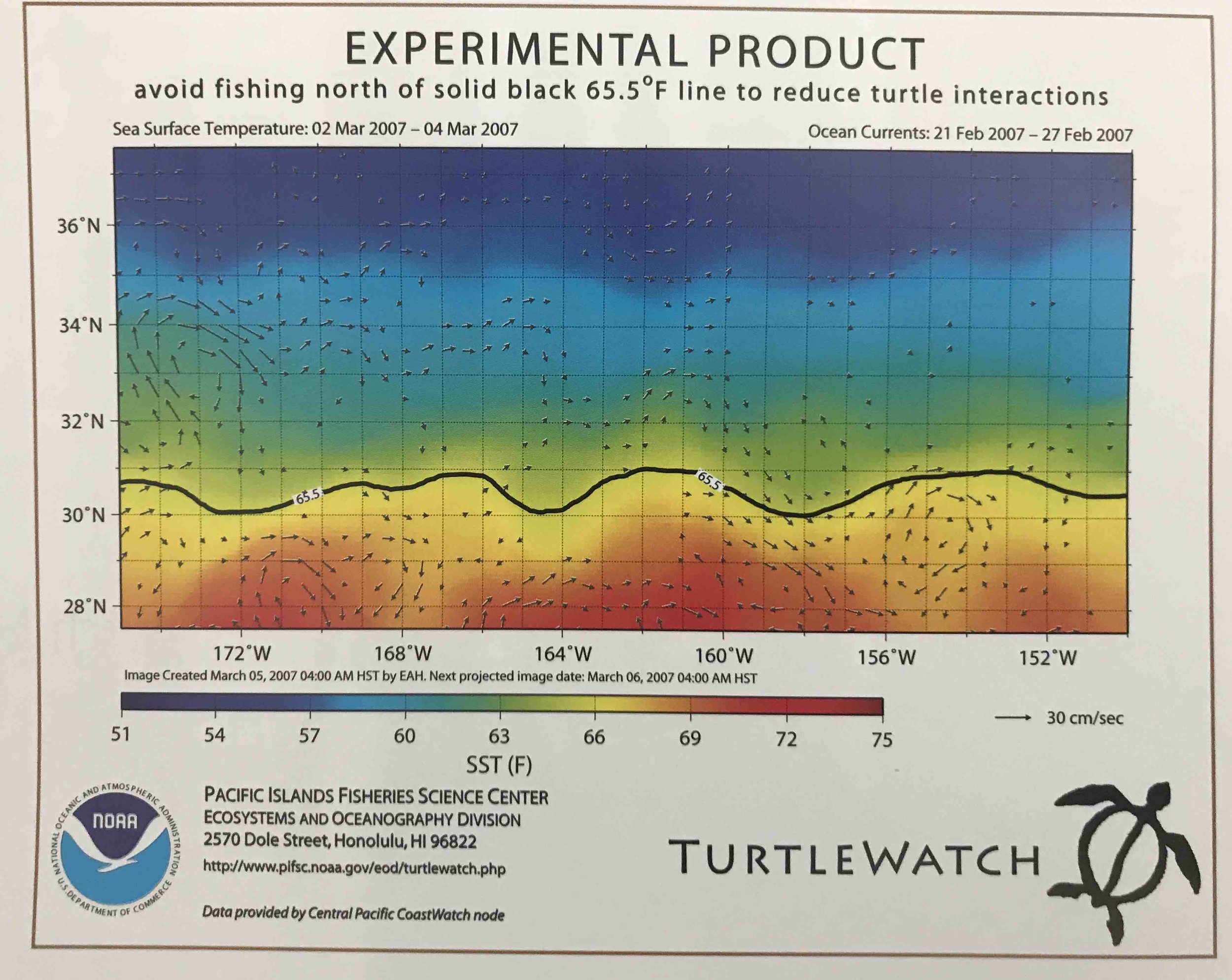
TurtleWatch uses the best available data on sea-surface temperature and ocean-current conditions to provide the predicted location of waters preferred by turtles. Because loggerheads tend to associate with the frontal system demarcated by a consistent 18°C (65°F) band of water north of Hawaii, TurtleWatch displays the predicted location of this temperature front and recommends that fishers avoid setting gear in that area (see figure at right).
When TurtleWatch was first released on December 26, 2006, its initial recommendation was that fishers avoid setting shallow longline gear targeting swordfish in areas of the north Pacific colder than 18.5ºC (65.5ºF). Automated updates were provided daily throughout the 2007 fishing season. In keeping with predictions, 65 percent of the loggerhead interactions with fishing gear occurred in the areas identified by TurtleWatch.
Building on information gathered during 2007, PIFSC made improvements to the TurtleWatch product for the 2008 fishing season, with a new recommendation that fishers avoid setting shallow gear where ocean temperatures were between 17.5ºC (~63.5ºF) and 18.5ºC (~65.5ºF) (see figure below). Additionally, in early 2008, GeoEye—a company providing oceanographic data services to the longline industry—began to distribute the TurtleWatch product to fishers, thereby increasing its use in the fishing community. Preliminary results indicate that TurtleWatch, in conjunction with other conservation steps taken by the longline industry, has been helpful: zero loggerhead turtle interactions have been reported in 2008 by the Hawaii-based longline fishery.
The final verdict on whether TurtleWatch is truly effective in reducing loggerhead bycatch will require further observation. Nonetheless, TurtleWatch achieved one of its primary objectives: an increased understanding and awareness of the critical overlap between the oceanic habitats of turtles and fishing activities. In this regard, TurtleWatch is already a success and serves as a novel model for future ecologically based conservation efforts designed to minimize undesirable interactions between fishing activities and protected species.
For more information about TurtleWatch, visit www.pifsc.noaa. gov/eod/turtlewatch.php.
This article originally appeared in SWOT Report, vol. 4 (2009). Click here to download the entire article as a PDF.